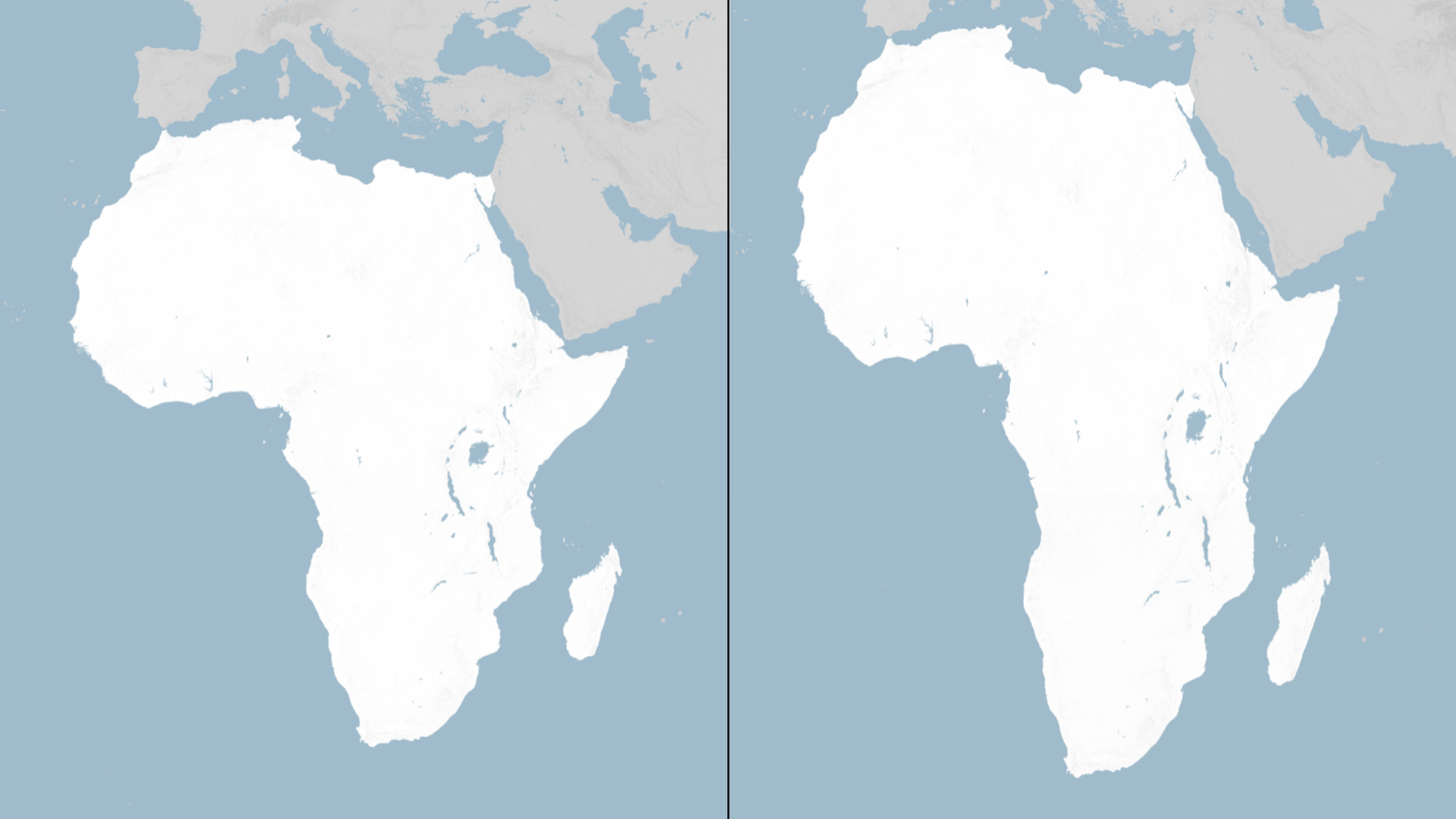
In a landmark move aimed at reshaping global perceptions, the United Nations General Assembly has voted to replace the traditional world map with a projection that more accurately reflects the true size of Africa, marking a significant victory for countries that have long argued that existing maps distort the continent’s scale and importance.
The resolution, titled “Correct the Map,” was sponsored by Togo and supported by members of the African Union (AU). It passed overwhelmingly with backing from 164 countries, including the United Kingdom and France. The United States was the only nation to vote against the measure, while six countries abstained.
Although the General Assembly’s vote is non-binding, it is expected to influence the maps used by international institutions, educational organizations and public bodies around the world. Supporters say the decision represents a step toward correcting historical misconceptions created by centuries-old cartographic conventions.
At the center of the debate is the Mercator projection, a map developed in 1569 by Flemish cartographer Gerardus Mercator to aid maritime navigation. While highly effective for sailing routes, the projection significantly distorts the relative size of landmasses. Countries and regions near the poles appear much larger than they actually are, while areas close to the equator, including Africa, appear considerably smaller.
As a result, Africa is often portrayed as being roughly comparable in size to Greenland, despite the continent being approximately 14 times larger. Critics argue that such distortions have shaped perceptions of Africa’s global significance, leading many to underestimate its size, resources and potential.
To address these concerns, cartographers introduced the Equal Earth projection in 2018, a mapping system designed to preserve the relative size of continents and countries more accurately. In February, all 54 African Union member states formally endorsed the projection, describing it as a fairer representation of the world’s geography, particularly Africa.
Advocates of the campaign argue that correcting geographical representations is about more than cartography. The online movement #CorrectTheMap has highlighted that Africa is so vast that it could accommodate the United States, China, India, Japan, Mexico and much of Europe within its borders while still having significant land area remaining.
Ahead of the vote, Togolese Foreign Minister Robert Dussey emphasized the symbolic importance of the measure, stating that a fair world begins with a fair map. Addressing a UN briefing earlier, he argued that maps are never neutral and play a powerful role in shaping perceptions of continents, nations and peoples.
Supporters believe the adoption of more accurate world maps will help challenge longstanding misconceptions and promote a better understanding of Africa’s true scale and global importance. The decision is being viewed as both a cartographic correction and a broader statement about representation, equity and how the world sees itself.





+ There are no comments
Add yours